Incredible Views Of The World's Cities After A Decade Of Watching Them From Space
This photo of Dubai, United Arab Emirates was taken in 2012. The blue mass at the center is the man-made Burj Khalifa "Lake." To its right is the Burj Khalifa tower, the tallest man-made structure in the world.

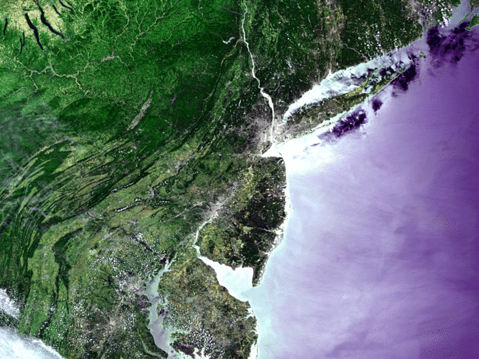
In this photo, this was taken by Envisat in 2005, you can see Manhattan nearly whited out by light pollution. It is the photo is colorized to show different terrains.
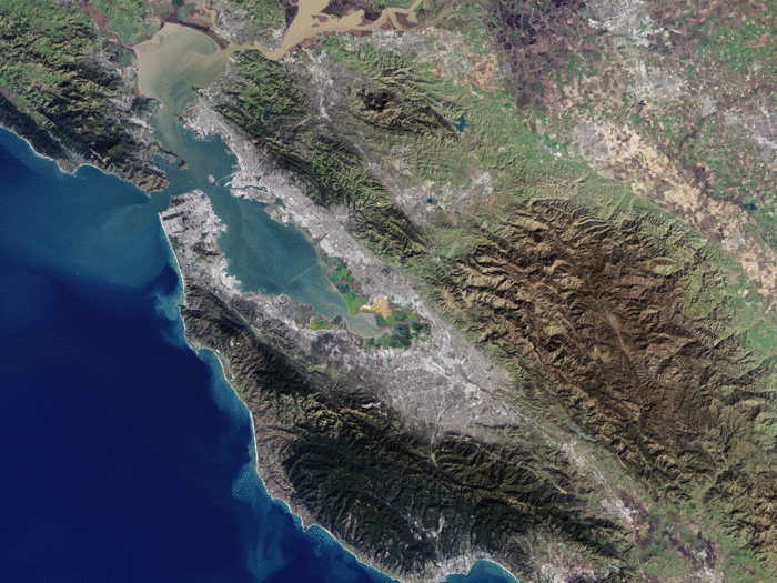
In this photo of the San Francisco Bay Area, you can see San Francisco on the peninsula in the center-left. The Golden Gate Bridge is just barely visible connecting the opening of the bay. The straight diagonal line running down the peninsula is the San Andreas Fault, responsible for the numerous earthquakes in the area.
This photo was taken by American satellite Landsat-7 in January. Landsat's goal is take cloud-free images of the Earth.
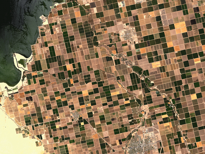
The Imperial Valley in Southern California is one of California's most productive agricultural regions. It begins at the Salton Sea (top left) and extends into Mexico. You can see the cities of Brawley (bottom right) and Westmorland (bottom left).
This was taken by ALOS, Japan's Earth observation satellite, shortly before it was decommissioned in 2011.
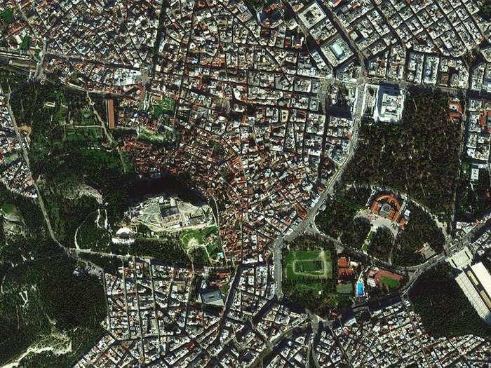
This photo of central Athens, Greece was taken this past January. In the center is the Acropolis of Athens. You can tell it is super tall — it casts a shadow it on the city to the north. In the lower right, you can see the large, white marble Panathenaic Stadium.
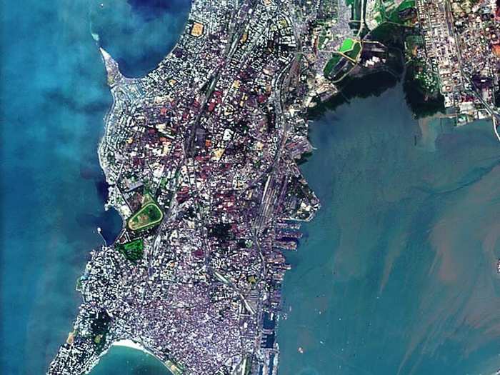
In this image of Mumbai, the Haji Ali mosque, a tomb for Muslim saint Haji and one of Mumbai's most popular tourist attractions, can be seen as a thin line attached to a square extending into the bay on the center-left. This was taken by one of the ESA's smallest satellites, Proba-1 in 2005.
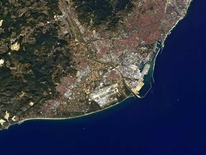
The Spanish city of Barcelona is pictured here. On the left, are the Garraf Massif Mountains. The large yellow patches are degraded land from rock quarries and garbage dumps. This was taken by Japan's ALOS satellite in 2011.
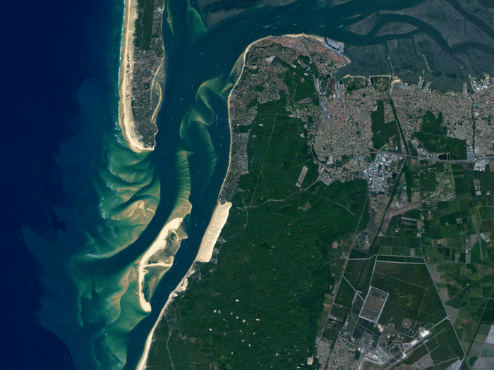
The Dune of Pyla in France (it looks like a light-brown rectangle near the center of this image) is the tallest sand dune in Europe. The large green area surrounding it is Landes Forest, Europe's largest maritime pine forest. At the top of landmass, you can see the city of Arcachon and Arcachon Bay. It was taken in 2009 by ALOS as well.
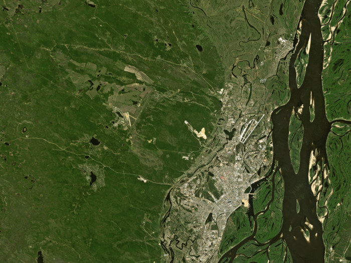
The city of Yakutsk in Russia is one of the coldest cities in the world. Average daily temperatures in January are -31 degrees Fahrenheit. ALOS captured this city in 2010.
This is the center of Brussels, Belgium. You can see Brussels Park in the center (green square with a triangle through it) and the Cinquantenaire Park to its right. Brussels is known for its many parks and green spaces. This image was taken by France's Spot-5 satellite in 2003.
Rotterdam is the Netherlands's second largest city. The port, which is the largest in Europe, can be seen on the left, a quarter way from the top. The city center is below it on the northern bank. It was taken by Envisat in 2007, using the ASAR instrument, which is what gives it such an odd coloration.
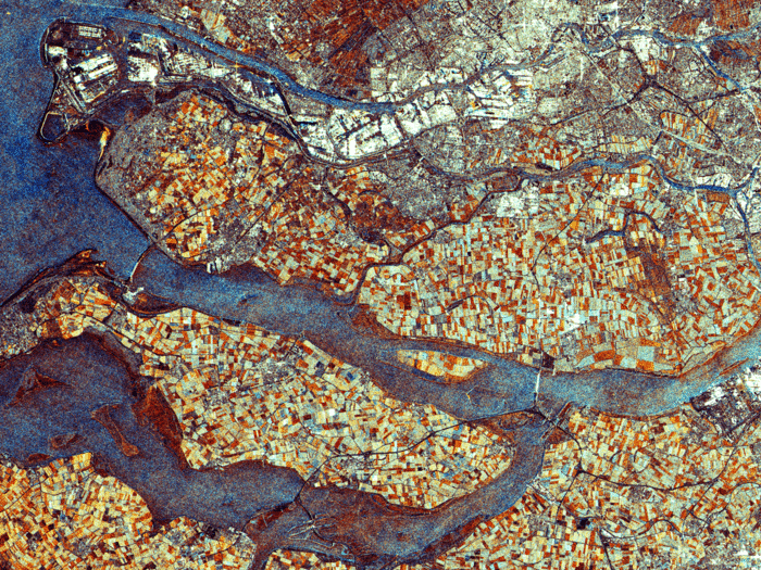
This image was taken by Envisat in 2007, using the ASAR instrument, which is what gives it such an odd coloration. It is at a resolution of 12.5 m.
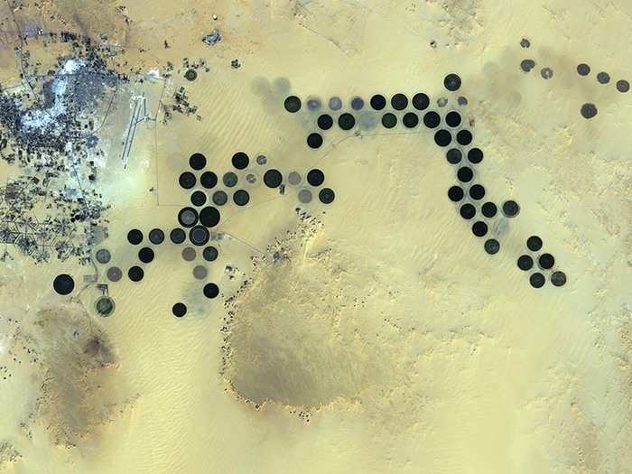
Deep in the Sahara desert is the Al Jawf oasis in Libya. Japan’s ALOS satellite caught the city in 2011. It is in the upper left corner, while the large circular dots are irrigated agricultural plots. They are circular because of a central pivot irrigation system that uses a rotating water pipe at the center of each plot. This city receives virtually no rainfall so it must pump water from deep underground.
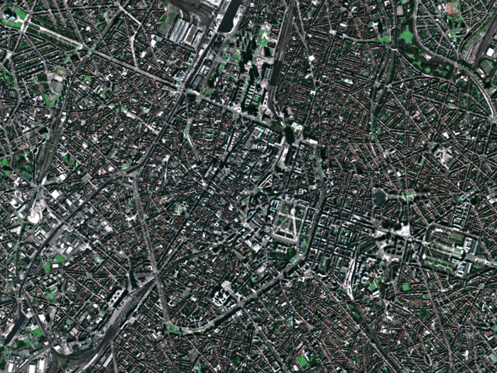
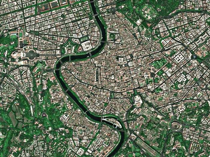
This photo of Rome, Italy was taken by France's Spot-5 satellite in 2005. The dark circle in the bottom right is the Coliseum, while Vatican City can be seen in the top third of the image to the left of the Tiber river.
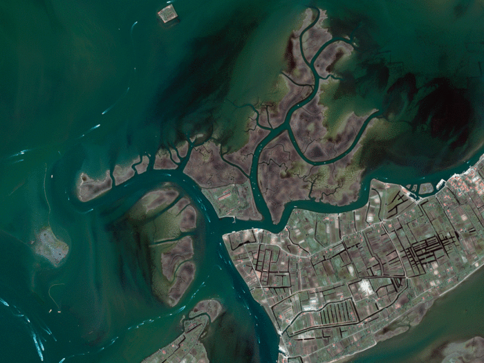
This photo of the Venetian Lagoon in Italy, taken in 2008 by the commercial satellite Ikonos-2, shows the busy waterways and islands northeast of Venice (not visible). The largest island is Saint Erasmus (center right) and Le Vignole (bottom left). The white marks in the lagoon's waterways are boat wakes.
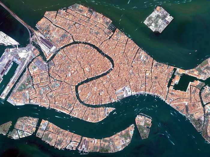
Another image from Ikonos-2 shows Venice's Grand Canal, the long waterway snaking through the center of the island. The square island to the north is San Michele, a former prison island that later became a cemetery when Napoleon's army declared burial on Venice to be unsanitary.
Now that you've seen Earth's cities from space...
Popular Right Now
Advertisement