Disturbing before-and-after images show what the San Francisco Bay Area could look like in 2100
Using satellites to measure the rate at which the land is sinking, the researchers behind the paper found that much of the city's coast is sinking at a rate of 2 millimeters per year, with some sections of the city sinking up to 10 millimeters per year.

By combining this new data on subsidence with known data on sea level rise, the researchers came to the conclusion that much more of the San Francisco Bay Area will be underwater by the end of the century than previously thought.

To put that into perspective, the researchers generated maps — based on different emissions-reduction scenarios —combining elevation data with predicted sea level rise and subsidence rates.
They found that current flooding projections underestimate how much of the area will actually be underwater by 2100 — by 3.7% at the low end and up to a whopping 90.9% at the high end. The researchers predict that up to 165 square miles of the Bay Area will be vulnerable to flooding in the future.
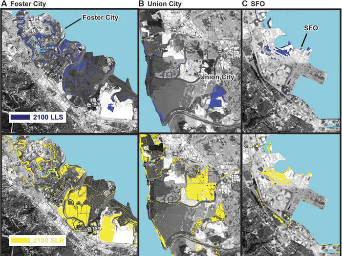
These maps show areas of the city — with the airport at the center — susceptible to flooding under three different scenarios.
The top map shows how much land will be underwater when only accounting for land subsidence (LLS). The yellow map in the middle depicts sea level rise (SLR).
The third scenario, in red on the bottom, shows the combination of sea level rise with the highest predicted rate of subsidence rate — leaving much of San Francisco International Airport, Foster City, and Union City underwater.
These new maps have powerful ramifications for insurance companies and the highly-valued properties on the Bay Area's coastline.
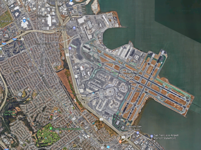
The airport, as well as properties around the airport, are particularly vulnerable to flooding. Over 53 million people fly in and out of San Francisco every single day — and that number is only increasing.
According to the researchers, there's not much we can do to stop the area from being flooded other than attacking the root causes of sea level rise by cutting emissions.
"There is no permanent solution to this problem," Shirzaei, one of the paper's authors told Wired. "The forces are immense, it's a very powerful process, the cost of really dealing with it is huge, and it requires long-term planning. I'm not so sure there's a good way to avoid it."

Popular Right Now
Popular Keywords
Advertisement