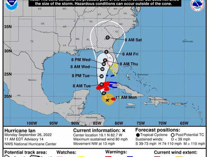
Hurricane Ian is expected to strike the Tampa Bay region as a major Category 3 storm on Wednesday.
National Hurricane Center
Hurricane Ian is churning toward Cuba, and forecasters expect it to rapidly gain strength in the warm Gulf waters as it approaches the western Florida coast.
Ian is expected to pass over the Cayman Islands Monday, then western Cuba on Monday night or early Tuesday. The National Hurricane Center (NHC) has issued a hurricane warning for the Cuban provinces of Isla de la Juventud, Pinar del Rio, and Artemisa.
On Monday at 2 p.m. ET, NHC said the storm was located about 195 miles southeast of Cuba's western top, traveling northwest at 13 mph.
As of that update, Ian was a Category 1 storm with 85 mph winds. But it's expected to churn itself up to 111 mph, a Category 3 storm, overnight or early Tuesday.
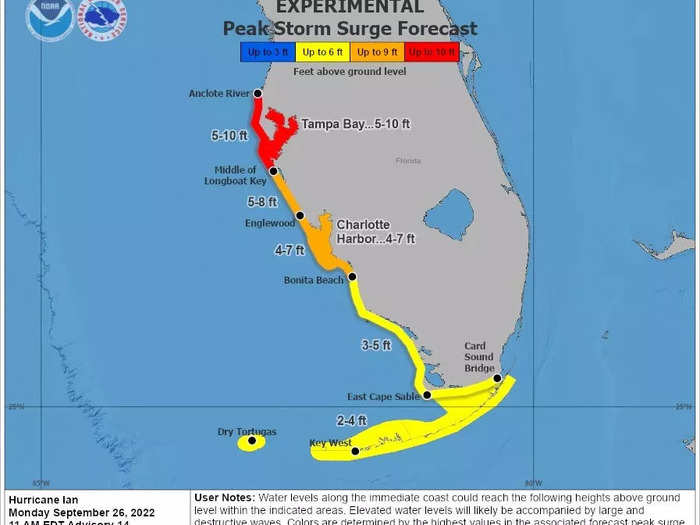
A hurricane watch is in effect across half of the Florida Gulf Coast, from Englewood to the Anclote River, including Tampa Bay, where NHC expects the heaviest storm surge — up to 10 feet of water.
Heavy rainfall is expected to bring flooding across Florida, including all the way east to Orlando.
"This is traditional rainfall flooding that will come and make movement difficult. So this is why you can't be waiting until the last minute to move around and make your preparations," Jamie Rhome, acting director of NHC, said in a livestream update Monday morning. In the Tampa Bay area, he added, preparations should be complete by Tuesday night.
Floridians should complete preparations on Tuesday and be ready to evacuate, forecasters advise.
Fishermen prepare to move their boats from a canal ahead of the arrival of Hurricane Ian in Havana, Cuba, on September 26, 2022. Alexandre Meneghini/Reuters
"You need to have your preparations finished by Tuesday morning, Tuesday noon at the latest," Rhome said.
Officials issued evacuation orders for parts of Hillsborough County, where Tampa is located, and Manatee County on Monday morning.
More evacuation orders are expected throughout Monday and Tuesday, in other areas where life-threatening storm surge is forecast. That influx of water is often more damaging and deadly than a cyclone's powerful winds.
Evacuation orders can be found on the website of the Florida Division of Emergency management, along with a map of evacuation zones.
"If emergency managers order you to leave, then you need to do so without question and without delay," Rhome said.
Tampa Bay could see a surge of up to 10 feet of ocean water.
National Hurricane Center
Other areas of Florida are expected to get 2 to 8 feet of storm surge. That influx of water is often more damaging and deadly than a cyclone's powerful winds.
Tampa city officials are handing out sand bags, and the county has put evacuation orders into effect.


